Aviemore has seen a rather belated Christmas (Picture: Paul Campbell/PA Wire)
Storm Goretti will bring even more wintry weather today as the Met Office issues amber and yellow weather warnings.
As much as 30cm of the white stuff could fall in the Midlands,while 90mph gusts could batter the coast.
Power outages,travel chaos and school closures are widely expected during this belated white Christmas.
Met Office meteorologist Alex Burkill said the storm will bring ‘wet,windy and wintry weather’ after the days-long cold snap.
He said Goretti,named by France’s weather service,will bring ‘some strong winds and some significant snow to central and perhaps southern parts’.
 Swans on the frosty Harnham Water Meadows in Salisbury with views of Salisbury Cathedral (Picture: Martin Cook / SWNS)
 Heavy snow is disrupting many parts of the Highlands (Picture: Paul Campbell/PA Wire)Amber warnings have an ‘increased likelihood of impacts from severe weather’ compared to yellow warnings.Met Office chief forecaster Neil Armstrong described Storm Goretti as a ‘multi-hazard event’ with heavy rain,strong winds and snow.He said up to 10cm of snow is likely widely in Wales and the Midlands,with 15-25cm and a potential for up to 30cm in some areas.Strong winds reaching speeds of up to 60mph will likely affect south-western areas this afternoon and evening,with gusts of 60-70mph along exposed hills and coasts.To find out if your area has a chance of snow,you can use our tracker map below:
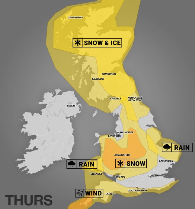 The UK is a patchwork of orange and yellow today (Picture: Metro)National Highways issued its own amber warning for snow in the West and East Midlands,which lasts from 6pm on Thursday until 9am on Friday.The agency said in a statement: ‘Routes particularly around Birmingham across to Leicester and Nottingham will see particularly difficult driving conditions and consideration of the weather forecast should be taken before commencing journeys,with considerable delays possible.”Drivers were also warned that the A628 Woodhead Pass would be closed both ways between the A616 at Flouch and the A57 at Hollingworth from 8pm on Thursday due to the severe weather.An amber wind warning from 5pm to 11pm on Thursday has been issued across parts of Cornwall and the Isles of Scilly,as forecasters warn of 80-90mph gusts in ‘exposed places’.
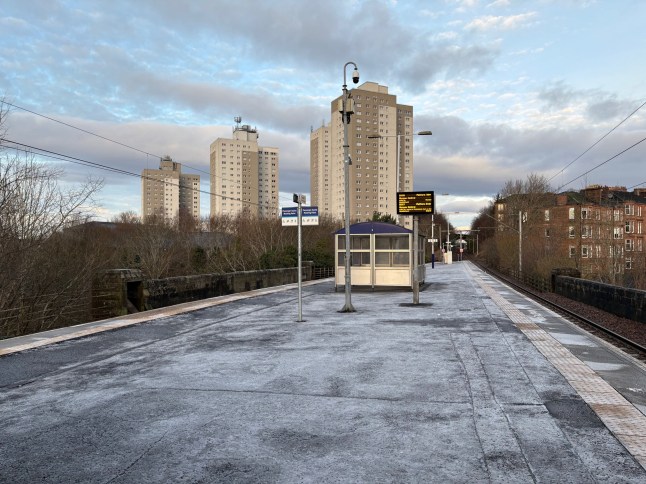 A frosty station platform on the southside of Glasgow. A yellow weather warning for snow and ice remains in place today (Picture: Lucinda Cameron/PA Wire)
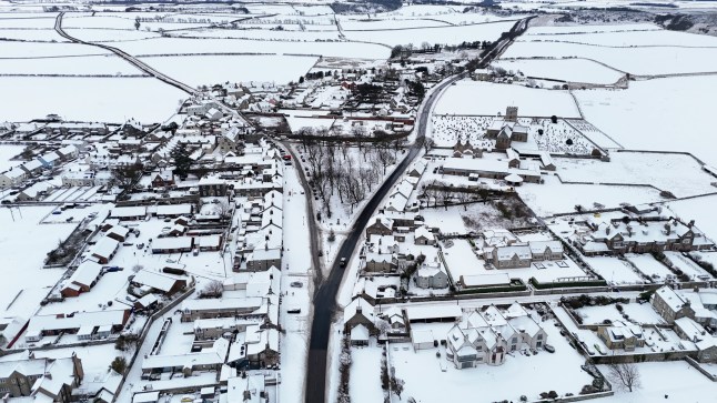 Snowy conditions are seen in Bamburgh,Northumberland,which is only partly affected by the weather warnings today (Picture: Owen Humphreys/PA Wire)There is a further yellow warning for wind for much of south-west England from 3pm on Thursday to 6am on Friday.There is also a yellow warning for snow and ice in Scotland from 10pm on Wednesday until midday on Thursday and a yellow warning for ice in Northern Ireland from midnight until 10am on Thursday.A yellow snow warning has been issued for a large part of England and much of Wales,and will be in place from 5pm on Thursday until midday on Friday.The Met Office said heavy snow may cause disruption and difficult travelling conditions.
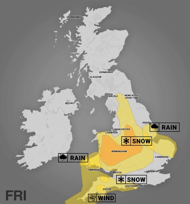 By Friday,things should have eased up a bit for Scotland and Northern Ireland,but the West and East Midlands,and the South West,are all under weather warnings (Picture: Metro)Burkill said 20cm or more of snow could settle,adding that is “enough to cause some severe disruption”.A yellow rain warning has also been issued across the east of England from 6pm on Thursday to 9pm on Friday,and in west Wales from midday on Thursday to 10am on Friday.Amber cold weather health alerts have been issued by the UK Health Security Agency until January 11,meaning severe impacts across health and social care services are expected.Officials expect a rise in deaths,particularly among those aged 65 and over or with health conditions,with impacts also possible on younger age groups.
Are any schools closed today?
Dozens of schools in Cornwall are closing early as Goretti bears down on the region:
Altarnun Primary School – closing at 2pm
Berrycoombe Primary – closing at 2pm
Bodmin College – closing at 2pm
Braddock CE School – closing at 2pm
Brannel School – closing at 2pm
Budehaven Community School – closing at 2pm
Callywith College – closing at 2:45pm
Camborne Science and International Academy – closing at 2pm
Chacewater Primary – closing at 2pm
Cury School – closing at 2pm
Darite Primary Academy – closing at 2pm
Doubletrees School – closing at 2pm
Egloskerry Primary – closing at 2pm
Fowey River Academy – closing at 2:10pm
Gerrans School – closing at 2pm
Grampound Road School – closing at 2pm
Grampound with Creed C of E School – closing at 2pm
Heamoor School – closing at 2pm
Helston Community College – closing at 2pm
Kea C P School – closing at 2pm
Kilkhampton Junior and Infant School – closing at 2pm
Lerryn Primary – closing at 2pm
Ludgvan School – closing at 2pm
Madron Daniel CofE – closing at 2:30pm
Mylor Bridge CP School – closing 2pm
Nancealverne School – closing at 2pm
Nanpean CP School – closing at 2pm
Newlyn School – closing at 2pm and opening late at 10am
Parc Eglos School – closing at 2pm
Pendeen School – closing at 2pm
Penwith Alternative Provision Academy – closing at 2pm
Perran-ar-Worthal CP School – closing at 2pm
Poltair School – closing at 2pm
Pool Academy – closing at 2pm
Quethiock CofE Primary School – closing at 2pm
Richard Lander School – closing at 2pm
St Catherine’s C of E School – closing at 2pm
St Day and Carharrack School – closing at 2pm
St Dennis Primary Academy – closing at 2pm
St Erme with Trispen School – closing at 2pm
St Erth Primary School – closing at 2pm
St Ives Junior School – closing at 2pm
St Just Primary School – closing at 2pm
St Levan Primary School – closing at 2pm
St Mabyn Church of England Primary School – closing at 2pm
St Martin’s C of E Primary School – closing at 1:45pm
St Mary’s C of E Primary – closing at 2:30pm
St Nicolas CE Primary – closing at 2pm
St Petroc’s Primary – closing at 2pm
Stratton Primary School – closing at 2pm
St Tudy Church of England Primary School – closing at 2pm
St Wenn School – closing at 2pm
The Roseland Academy – closing at 2:05pm
Tregadillett Primary – closing at 2pm
Tregony C P School – closing at 2pm
Trenode Primary Academy – closing at 2pm
Trewirgie Infant School – closing at 2pm
Trythall Community Primary School – closing at 2pm
Wadebridge Primary Academy – closing at 2pm
The NHS advises that if you do need to head outside today,‘waddle like a penguin’ to stay safe on the icy pavements.
By sticking your arms out and taking short,shuffling steps,you keep your centre of gravity close to your feet,so are less likely to wobble.
But get used to waddling,Jim Dale,a forecaster who founded British Weather Services, told Metro.
He said: ‘The storm will dump the snow,especially across Wales and the Midlands. Not eight inches,but more like five inches or 12cm.
‘Scotland of course have much,much more even now.’
Dale said that as blob of Polar air is behind the cold snap and has been hovering above the UK for about a week now.
He added: ‘It’s slightly less cold today as we await the storm.’
United News - unews.co.za